Pak Imtehan
Competitive Exams Prep App
The South China Sea serves as a critical artery for global commerce and a primary theater for geopolitical competition. Extending from the Singapore and Malacca Straits in the southwest to the Taiwan Strait in the northeast, this marginal sea encompasses approximately 3.5 million square kilometers. Its significance is derived from a combination of maritime trade routes, hydrocarbon reserves, and protein security through fisheries.
Data from the United Nations Conference on Trade and Development (UNCTAD) indicates that roughly one third of global shipping passes through these waters. This includes over 60% of China’s maritime trade and a significant portion of energy imports for Japan and South Korea. Beneath the seabed, the U.S. Energy Information Administration (EIA) estimates the region holds approximately 11 billion barrels of oil and 190 trillion cubic feet of natural gas in proved and probable reserves.
The convergence of these economic interests with overlapping territorial claims has transformed the South China Sea into a focal point of international friction. The primary actors include China, Taiwan, Vietnam, the Philippines, Malaysia, and Brunei. While the disputes are rooted in historical grievances, they are increasingly defined by the application and rejection of modern international maritime law.
The Legal Framework: UNCLOS and Maritime Zones
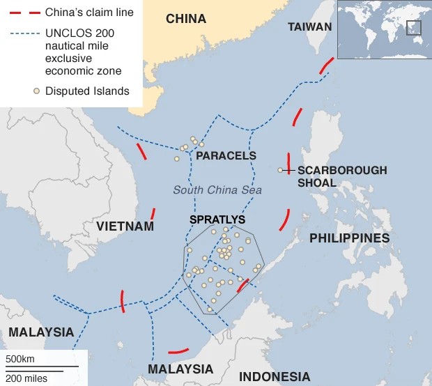
The foundational legal instrument governing these waters is the United Nations Convention on the Law of the Sea (UNCLOS), which came into force in 1994. Under UNCLOS, coastal states are entitled to specific maritime zones measured from their baselines:
Territorial Sea: A zone extending 12 nautical miles from the coast, where the state exercises full sovereignty.
Exclusive Economic Zone (EEZ): A zone extending up to 200 nautical miles, granting the state sovereign rights to explore, manage, and exploit natural resources.
Continental Shelf: The submerged prolongation of a state's land territory, which can extend beyond 200 nautical miles under specific geological conditions.
Source: BBC
The South China Sea dispute arises because these zones overlap. Furthermore, the legal status of geographic features whether they are islands, rocks, or low tide elevations determines the extent of maritime space a claimant can legally control. Under UNCLOS Article 121, an island must be capable of sustaining human habitation or economic life to generate an EEZ. Features that do not meet this criteria are classified as rocks, which only generate a 12 nautical mile territorial sea.
China’s Nine Dash Line and Historical Claims
The most expansive claim in the region is asserted by the People’s Republic of China (PRC), demarcated by the Nine Dash Line. This U-shaped perimeter encompasses nearly 80% of the South China Sea, cutting into the EEZs of several Southeast Asian nations.
Beijing’s claim is predicated on historical rights, asserting that Chinese fishermen and naval expeditions have utilized the waters and islands for centuries. This position often stands in direct opposition to the text of UNCLOS. China argues that its sovereignty over the Paracel and Spratly Islands predates the modern legal framework and that these island groups should be treated as integrated archipelagos capable of generating vast maritime zones.
The Nine Dash Line originated from a map published by the Republic of China (Taiwan) in 1947, which the PRC subsequently adopted. While China has not provided precise geographic coordinates for the dashes, its actions including patrol operations and resource extraction suggest an interpretation of the line as a boundary for historic title over the waters and the seabed.
Territorial Clusters: The Paracels and Spratlys
The dispute is concentrated on two primary island groups: the Paracel Islands and the Spratly Islands.
The Paracel Islands
Located in the northern part of the sea, the Paracels are contested by China, Taiwan, and Vietnam. In 1974, Chinese forces seized control of the western Crescent Group from South Vietnamese forces following a brief naval engagement. Since then, China has maintained de facto control over the entire archipelago. Vietnam continues to assert its claim based on historical administration during the French colonial era and prior Vietnamese dynasties.
The Spratly Islands
The Spratlys consist of more than 100 small islands, reefs, and atolls scattered across the southern portion of the sea. This area is the most complex sector of the dispute, with claims from China, Taiwan, Vietnam, the Philippines, and Malaysia. Unlike the Paracels, the Spratlys are characterized by a fragmented occupation. Different nations hold various outposts, often within sight of one another, leading to frequent naval standoffs and diplomatic protests.
Land Reclamation and Militarization
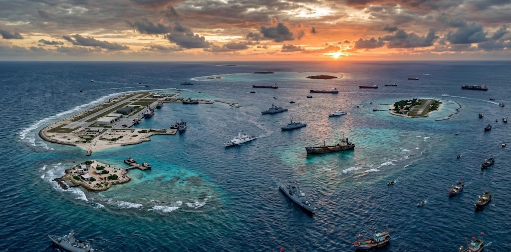
Since 2013, the nature of the dispute has shifted from diplomatic posturing to physical transformation of the maritime environment. China initiated large scale land reclamation projects on several features in the Spratly Islands, including Subi Reef, Mischief Reef, and Fiery Cross Reef. By dredging sand from the ocean floor and placing it onto coral reefs, Beijing created approximately 3,000 acres of new land.
These artificial islands have been progressively militarized. Satellite imagery and intelligence reports confirm the installation of long range sensor arrays, anti ship and anti aircraft missiles, and reinforced hangars capable of supporting fighter jets. While other claimants, such as Vietnam and the Philippines, have also expanded their outposts, the scale and technological sophistication of China’s construction are unprecedented.
This strategy allows a claimant to change the facts on the ground through incremental steps, none of which individually trigger a full scale military conflict but which collectively alter the regional balance of power.
The 2016 Permanent Court of Arbitration Ruling
A pivotal moment in the legal history of the dispute occurred when the Philippines initiated an arbitration case against China under UNCLOS in 2013. The Permanent Court of Arbitration (PCA) in The Hague issued its final award on July 12, 2016.
The tribunal’s findings were comprehensive and largely favored the Philippines:
Historic Rights: The court ruled that China’s Nine Dash Line had no legal basis under international law to the extent it exceeded the maritime zones permitted by UNCLOS.
Status of Features: The court determined that none of the features in the Spratly Islands were legally islands capable of generating an EEZ. They were classified as either rocks or low tide elevations.
Environmental Damage: The tribunal found that China’s land reclamation activities had caused irreparable harm to the coral reef ecosystem.
China refused to participate in the proceedings and declared the ruling "null and void." Beijing continues to ignore the decision, maintaining that the tribunal lacked jurisdiction over issues of sovereignty. Despite its lack of enforcement, the 2016 ruling remains a critical legal benchmark for other Southeast Asian nations and the international community.
The Role of Southeast Asian Claimants
The Association of Southeast Asian Nations (ASEAN) has attempted to manage the dispute through multilateral diplomacy, though internal divisions have hindered a unified response.
The Philippines
Under different administrations, Manila has vacillated between confrontational and conciliatory approaches toward Beijing. However, persistent harassment of Filipino resupply missions to Second Thomas Shoal where the Philippines maintains a grounded naval vessel, the BRP Sierra Madre, as an outpost has led to a hardening of Manila's stance. The Philippines has increasingly sought to bolster its defense alliance with the United States to deter Chinese incursions.
Vietnam
Vietnam employs a strategy of struggling and cooperating. It maintains robust economic ties with China while simultaneously modernizing its military and seeking closer security partnerships with the United States, India, and Japan. Hanoi’s claims are based on both historical records and the continental shelf principle under UNCLOS.
Malaysia and Brunei
Malaysia and Brunei have traditionally adopted a more quietist approach, focusing on the protection of their offshore oil and gas interests. However, frequent intrusions by the China Coast Guard (CCG) into Malaysia’s EEZ near Luconia Shoals have prompted more frequent diplomatic protests from Kuala Lumpur.
The United States and Freedom of Navigation
Although the United States is not a claimant and has no official position on the sovereignty of the islands, it maintains a significant interest in the South China Sea. Washington views the region through the lens of freedom of navigation and the maintenance of a rules based international order.
The U.S. Navy regularly conducts Freedom of Navigation Operations (FONOPs), sailing warships within 12 nautical miles of disputed features to challenge what it deems excessive maritime claims. These operations are intended to signal that the U.S. does not recognize any restrictions on navigation that are inconsistent with international law.
The U.S. China rivalry in the South China Sea is a core component of a broader competition for regional hegemony. As Admiral Philip Davidson, former Commander of the U.S. Indo-Pacific Command, noted: “China is now capable of controlling the South China Sea in all scenarios short of war with the United States.”
Environmental and Economic Consequences
The geopolitical focus often obscures the severe ecological degradation occurring in the South China Sea. The region accounts for roughly 12% of the global fish catch, supporting the livelihoods of millions. However, overfishing, destructive fishing practices such as the use of cyanide and explosives, and habitat destruction from land reclamation have led to a collapse in fish stocks.
The militia fleets commercial fishing vessels that act as an extension of national maritime forces exacerbate this issue. These vessels often congregate in disputed waters to assert presence, leading to the depletion of resources in areas where local fishermen have traditionally operated. The absence of a shared management framework for fisheries creates a tragedy of the commons that threatens regional food security.
Regarding energy, the dispute has stalled many planned oil and gas projects. International energy firms are often reluctant to operate in contested blocks due to the risk of harassment by foreign naval or coast guard vessels. This prevents Southeast Asian nations from fully realizing the economic potential of their offshore resources.
Diplomacy and the Code of Conduct (CoC)
Since 2002, ASEAN and China have been engaged in negotiations for a Code of Conduct (CoC) in the South China Sea. The goal is to establish a set of norms and rules to prevent accidents and manage tensions.
Progress has been slow, hampered by disagreements over:
Geographic Scope: Whether the CoC should cover the entire sea or only specific disputed areas.
Legal Status: Whether the agreement should be legally binding or a voluntary set of guidelines.
Third Party Involvement: China has pushed for clauses that would restrict Southeast Asian nations from conducting joint military exercises or resource exploration with outside powers.
As long as these fundamental disagreements persist, the CoC is unlikely to provide a definitive resolution to the conflict.
Strategic Implications of Gray Zone Tactics
The South China Sea is a primary venue for gray zone warfare actions that fall below the threshold of armed conflict but are designed to achieve strategic objectives. This involves the use of the China Coast Guard and the People’s Armed Forces Maritime Militia (PAFMM) rather than the People’s Liberation Army Navy (PLAN).
By using non military vessels to harass foreign ships, block resupply missions, and shield fishing fleets, claimants can exert pressure without providing a clear justification for a military response. These tactics exploit the ambiguities of international law and the reluctance of regional states to escalate to kinetic warfare.
The use of high pressure water cannons, laser dazzlers, and professional collisions has become a routine feature of interactions between the CCG and the Philippine Coast Guard. These incidents carry a high risk of miscalculation, where a tactical error by a ship captain could escalate into a wider strategic confrontation.
Conclusion: The Path Forward
The South China Sea dispute is unlikely to be resolved through a single grand bargain or legal settlement. The positions of the various claimants are deeply entrenched in national identity and economic necessity. The overlapping claims represent a fundamental tension between historical based sovereignty and law based maritime jurisdiction.
The stability of the region depends on the ability of the actors to manage tensions through communication channels and to adhere to a baseline of international norms. While the risk of accidental escalation remains high, the economic interdependence of the surrounding nations acts as a countervailing force against full scale conflict.
The South China Sea remains a bellwether for the future of international law. Whether the disputes are managed through the application of UNCLOS or through the exercise of raw power will determine the character of the security architecture in the Indo-Pacific for decades to come. The continued militarization of the region and the stalemate in diplomatic negotiations suggest that the South China Sea will remain among the world's most contested and volatile waterways.
Comments (0)
No comments yet. Be the first to comment!