Pak Imtehan
Geopolitical Analyst
Borders Explained: How Countries Draw Their Lines
Begin with a Map Exercise
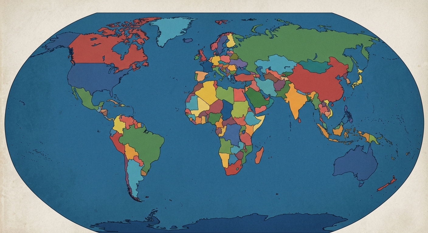
Take a moment to picture a world map in your mind. Now look closely at three regions.
North Africa and the Middle East: Notice how many borders run in perfectly straight lines across the desert, as if drawn with a ruler.
Europe: Notice how many borders twist and turn, following rivers, mountain ridges and coastlines.
North America: Notice the long, straight line between the United States and Canada running for over 2,000 kilometres across the western plains.
Why would some borders follow the shape of the land while others ignore it completely? Who decided where these lines should go, and when? And why do some of them remain peaceful for centuries while others become the scene of war?
The answers reveal one of the most important and least understood features of world politics. Borders are not natural facts. They are human decisions, shaped by geography, history, power and, quite often, by people sitting at a table thousands of kilometres away from the land they were dividing.
What a Border Actually Is
A border, or international boundary, is the line that marks the limit of a state’s territory and sovereignty. On one side, one government’s laws apply. Step across, and a different set of laws, taxes, languages, currencies and often an entirely different way of life begins.
It helps to separate three related terms that are often confused:
Boundary: the precise legal line, defined in treaties and maps.
Border: the boundary as it exists on the ground, including checkpoints, fences, guards and customs posts.
Frontier: historically, a broad zone between territories where control was loose or contested, rather than a sharp line. Before the modern era, many empires ended not at a line but in a vague frontier region.
The move from frontiers to sharply defined lines is itself a modern development. For most of human history, rulers cared more about controlling people and cities than about marking exact edges on a map. The precise, mapped border became standard only with modern surveying, the rise of the sovereign state and the age of European empires.
Today, the world contains more than 300 international land boundaries. The longest is the border between Canada and the United States, which stretches for 8,891 kilometres, including the boundary with Alaska.
The Four Stages of Drawing a Border
How does a line actually come into being? In his classic handbook Boundary-Making (1945), the American geographer Stephen B. Jones described four stages that most borders pass through:
Allocation: a political decision about which territory belongs to which state, often reached through war, treaty or negotiation.
Delimitation: the precise description of the boundary in a treaty, using words, coordinates and maps.
Demarcation: marking the line on the ground with pillars, posts, fences, walls or buoys.
Administration: managing the border over time, including checkpoints, customs, patrols and the resolution of local disputes.
Many border disputes arise because one of these stages was done badly. A treaty may describe a line vaguely. A map may contain errors. A river named as the border may change course. A demarcation team may never have reached remote mountain areas. Each gap can become a source of conflict decades later.
Pause and consider: Imagine two neighbouring countries agree in a treaty that their border follows “the highest ridge of the mountains.” What problems might arise when surveyors arrive and discover several ridges of nearly equal height?
Natural and Artificial Lines
Borders are often divided into two broad categories based on how they relate to the land.
Natural Borders
Natural, or physical, borders follow features of the landscape.
Mountains: The Pyrenees separate France and Spain. The Andes form much of the long border between Chile and Argentina.
Rivers: The Rio Grande forms part of the border between the United States and Mexico. The Amur and Ussuri rivers mark much of the boundary between Russia and China.
Lakes: The Great Lakes divide Canada and the United States, and Lake Victoria is shared by Uganda, Kenya and Tanzania.
Seas and straits: Many island states are defined entirely by the sea around them.
Natural borders are easy to identify and often easier to defend, which is why rulers have long favoured them. They are not, however, free of problems:
Rivers move. Over time, rivers change course. The shifting of the Rio Grande in the nineteenth century created the Chamizal dispute between the United States and Mexico over a piece of land near El Paso. It was finally settled by the Chamizal Convention of 1963, which returned most of the disputed land to Mexico.
Mountains are hard to measure. Treaties that refer to watersheds or ridges can produce disagreements once surveyors reach the terrain.
Natural features may divide communities. A river can split villages and families that have shared the same valley for generations.
Artificial or Geometric Borders
Artificial, or geometric, borders are drawn without regard to physical features, usually following lines of latitude and longitude or straight lines between fixed points.
The border between Canada and the United States follows the 49th parallel for a long stretch west of the Great Lakes, a line agreed in 1818 and extended to the Pacific by the Oregon Treaty of 1846.
Large parts of the borders between Egypt, Libya and Sudan run in straight lines across the Sahara.
Many internal boundaries, such as those between the American states of Colorado and Wyoming, are also geometric.
Geometric borders are simple to describe in treaties and quick to draw on maps. Their weakness is that they often ignore how people actually live, cutting through grazing lands, trade routes, tribes and language communities.
Classifying Borders by Their History
In 1936, the American geographer Richard Hartshorne proposed another way to classify borders: by when they were drawn in relation to the people living around them. His four categories remain widely used:
Antecedent borders were drawn before the area was heavily settled. The 49th parallel between the United States and Canada is a classic example, because it was drawn when much of the region was thinly populated.
Subsequent borders were drawn after settlement, usually following existing cultural or ethnic divisions. Many borders in Europe developed this way over centuries.
Superimposed borders were imposed by outside powers, often with little regard for the people living there. Many colonial borders in Africa and the Middle East fall into this category.
Relict borders no longer function as political boundaries but remain visible in the landscape or in people’s lives. The former line of the Berlin Wall, which divided the city from 1961 to 1989, is the most famous example.
Quick check: Which category would describe a border drawn by two European empires across a region whose inhabitants were never consulted? (Answer: superimposed.)
Lines Drawn from Afar: Empires and Their Maps
Some of the most consequential borders in the world were drawn by powers far from the territories concerned.
Dividing the World in 1494
In the Treaty of Tordesillas (1494), Spain and Portugal agreed to divide newly discovered lands outside Europe along a line 370 leagues west of the Cape Verde islands. Lands to the west would go to Spain and those to the east to Portugal. This explains why Brazil, which lies partly east of that line, speaks Portuguese while most of South America speaks Spanish.
The Scramble for Africa
At the Berlin Conference of 1884 to 1885, European powers met to set rules for claiming African territory. No African rulers were invited. The conference did not itself draw most of Africa’s borders, but it accelerated a rapid partition of the continent over the following decades. Colonial powers frequently drew lines along rivers, lines of latitude and longitude, or simple straight lines. By common estimates, around 44 percent of Africa’s borders follow straight lines or geometric arcs.
The consequences have been lasting:
Some ethnic groups were divided between several colonies. The Maasai, for example, are split between Kenya and Tanzania, and the Somali people were divided among several territories.
Rival communities were sometimes placed together inside a single colony, which later became a single independent state.
When African states gained independence, they faced a difficult choice: redraw the colonial borders or keep them. In 1964, the Organisation of African Unity, meeting in Cairo, chose stability. Member states pledged to respect the borders that existed at the moment of independence, fearing that any attempt to redraw them would open endless conflicts.
The Sykes-Picot Agreement
During the First World War, Britain and France secretly negotiated the Sykes-Picot Agreement (1916), dividing much of the Arab provinces of the Ottoman Empire into zones of influence. The final borders of states such as Iraq, Syria, Lebanon and Jordan were shaped by later agreements and League of Nations mandates, but Sykes-Picot became a lasting symbol of borders imposed by outside powers. When the armed group known as the Islamic State bulldozed part of the Iraq-Syria border in 2014, it explicitly claimed to be destroying the legacy of Sykes-Picot.
The Principle That Freezes Borders
How can states that inherited colonial borders avoid endless wars over them? International law developed an answer known as uti possidetis juris, a Latin phrase meaning roughly “as you possess under law, so you shall possess.”
Under this principle, newly independent states inherit the administrative boundaries that existed under colonial rule.
It was first applied widely in Latin America in the nineteenth century, as former Spanish colonies became independent states.
It was later adopted across Africa through the Organisation of African Unity’s 1964 decision.
The International Court of Justice affirmed it as a general principle in the Frontier Dispute case between Burkina Faso and Mali in 1986.
It was also applied when the Soviet Union and Yugoslavia broke apart, with the former internal republic boundaries becoming international borders.
The principle has prevented many wars, but at a cost: borders that were often drawn without regard for local populations became permanent.
Borders That Divide, Borders That Puzzle
Not every border is a simple line between two countries. Some of the world’s boundaries are remarkable for their strangeness.
A border through a café. In the town of Baarle, Belgian and Dutch territory are intertwined in a patchwork of dozens of small enclaves. The border runs through streets, gardens and even buildings, and some houses sit partly in Belgium and partly in the Netherlands.
Land no country wants. Between Egypt and Sudan lies Bir Tawil, an area of about 2,060 square kilometres that neither country claims. The reason is that Egypt prefers a border drawn in 1899, which gives it the valuable Halaib Triangle, while Sudan prefers a line drawn in 1902, which gives the Halaib Triangle to Sudan instead. Under either line, Bir Tawil falls to the other side, so neither government claims it.
A border that became a fortress. The Korean Demilitarised Zone (DMZ) runs for about 250 kilometres across the Korean Peninsula and is about 4 kilometres wide. It follows the ceasefire line of 1953 and remains one of the most heavily fortified borders in the world.
A border that disappeared. Within the Schengen Area, created by an agreement signed in 1985, people can travel between 29 European countries without routine passport checks. Borders still exist legally, but for millions of travellers they are almost invisible.
When Lines Lead to War
Disputes over borders have been among the most common causes of interstate war. A few cases illustrate the pattern.
Ethiopia and Eritrea. In 1998, a dispute over the small town of Badme led to a war that killed tens of thousands of people. After the Algiers Agreement of 2000, an independent boundary commission awarded Badme to Eritrea in 2002, but tensions continued until the two countries signed a peace agreement in 2018.
Iraq and Kuwait. In 1990, Iraq invaded Kuwait, partly justifying the attack by questioning the border and claiming Kuwait as historically Iraqi territory. After the Gulf War, a United Nations commission demarcated the boundary in 1993.
The South China Sea. At sea, borders are just as contested. China’s claims, represented by a “nine-dash line” covering most of the South China Sea, overlap with those of Vietnam, the Philippines, Malaysia, Brunei and others. On 12 July 2016, an arbitral tribunal under the United Nations Convention on the Law of the Sea (UNCLOS) ruled in a case brought by the Philippines that China’s claims to historic rights within the line had no legal basis. China rejected the ruling.
Pause and consider: Why might a country be willing to fight a war over a small, poor piece of land such as Badme? What does that land represent beyond its physical value?
Borders at Sea
Borders do not stop at the coastline. Under UNCLOS, adopted in 1982, maritime boundaries are measured from a country’s coast:
Territorial sea: up to 12 nautical miles, under full sovereignty.
Contiguous zone: up to 24 nautical miles, where the state can enforce customs, immigration and sanitary laws.
Exclusive Economic Zone (EEZ): up to 200 nautical miles, where the state controls fishing, oil, gas and other resources.
Where the zones of neighbouring states overlap, as they often do in narrow seas, countries must negotiate boundaries or turn to courts and arbitration. Because these zones can contain enormous reserves of oil, gas and fish, maritime borders are often fiercely disputed.
Pakistan’s Borders: A Case Study
Pakistan’s borders show how history, geography and diplomacy combine in drawing national lines.
The Durand Line. Pakistan’s western border with Afghanistan follows the Durand Line, established in 1893 by an agreement between Sir Mortimer Durand, a British official, and Amir Abdur Rahman Khan, the ruler of Afghanistan. The line runs for about 2,600 kilometres through mountainous terrain and divided Pashtun and Baloch tribal communities.
Pakistan’s position: Pakistan regards the Durand Line as its internationally recognised border, inherited from British India under the principle of succession.
Afghanistan’s position: successive Afghan governments have declined to formally recognise it as a permanent international border.
Recent developments: since 2017, Pakistan has built a fence along much of the line to improve security and regulate movement.
The border with China. Pakistan and China signed a boundary agreement on 2 March 1963, settling their frontier in the high mountains of the north. The agreement is often cited as an example of two states resolving a boundary through negotiation, and it laid an early foundation for close relations, later symbolised by the Karakoram Highway through the Khunjerab Pass.
The border with Iran. Pakistan’s border with Iran, running for around 900 kilometres through Balochistan, has its origins in boundary work carried out under British rule in the late nineteenth century and was later confirmed by agreements between the two states.
The maritime boundary. Pakistan’s coastline on the Arabian Sea gives it territorial waters and an Exclusive Economic Zone under UNCLOS. In 2015, the United Nations Commission on the Limits of the Continental Shelf accepted Pakistan’s claim to an extended continental shelf beyond 200 nautical miles, adding a large area of seabed to its maritime jurisdiction.
The Future of Borders
Two opposite trends are shaping borders in the twenty-first century.
Borders are becoming more open in some places. Regional arrangements such as the Schengen Area, free trade agreements and digital connectivity allow goods, money, ideas and people to cross borders more easily than ever.
Borders are becoming harder in others. At the end of the Cold War, only a handful of border walls existed around the world. Today there are dozens, built to control migration, smuggling and militant movement. Examples include barriers along parts of the United States-Mexico border, fences on the borders of several European states, and Pakistan’s fence along the Durand Line.
New questions are also emerging:
Climate change: rising seas may change coastlines and, with them, the starting points from which maritime zones are measured.
Melting ice: as Arctic ice retreats, states are paying closer attention to boundaries and resource rights in the far north.
Cyberspace: governments increasingly speak of digital borders, seeking to control data and online activity within their territory.
Borders, it turns out, are never finished. They are drawn, contested, redrawn, opened and closed again as circumstances change.
Test Yourself
What are the four stages of boundary-making described by Stephen B. Jones?
Give one example each of a natural border and a geometric border.
Which of Hartshorne’s categories describes the former Berlin Wall?
What does uti possidetis juris mean, and why did African states adopt it?
Why does neither Egypt nor Sudan claim Bir Tawil?
Conclusion
Every border on the world map tells a story. Some follow mountains and rivers that separated communities long before modern states existed. Others were drawn with rulers by distant empires, dividing peoples and lands without their consent. Some have been accepted peacefully for centuries, while others continue to provoke tension and war.
Understanding how borders are drawn, through allocation, delimitation, demarcation and administration, and how they are classified, whether natural or geometric, antecedent or superimposed, helps explain why so many conflicts begin at the edges of states. The lines may look fixed on a map, but they are the product of human choices, and human choices can always be challenged.
Frequently Asked Questions
What is the difference between a border and a boundary?
A boundary is the precise legal line defined in treaties and maps. A border usually refers to that line as it exists on the ground, including fences, checkpoints and customs posts. In everyday use, the two words are often treated as the same.
How are international borders decided?
Borders are usually decided through treaties, negotiations, wars, colonial agreements or decisions by international courts and arbitration panels. They then go through stages of delimitation in legal documents and demarcation on the ground.
What are natural and artificial borders?
Natural borders follow physical features such as mountains, rivers, lakes and seas. Artificial, or geometric, borders are drawn without regard to the landscape, often following lines of latitude and longitude or straight lines between points.
Why are so many African borders straight lines?
Many African borders were drawn by European colonial powers in the late nineteenth and early twentieth centuries, often using lines of latitude and longitude or straight lines on maps. These borders frequently ignored existing ethnic, linguistic and political communities.
What was the Berlin Conference?
The Berlin Conference of 1884 to 1885 was a meeting of European powers that set rules for claiming territory in Africa. No African representatives took part. It accelerated the colonial partition of the continent.
What is uti possidetis juris?
It is a principle of international law under which newly independent states inherit the administrative boundaries that existed under colonial or previous rule. It was applied in Latin America and Africa and affirmed by the International Court of Justice in 1986.
What is the longest international border in the world?
The border between Canada and the United States is the longest, stretching for 8,891 kilometres, including the boundary between Canada and Alaska.
What is the Durand Line?
The Durand Line is the border between Pakistan and Afghanistan, established in 1893 by an agreement between British official Sir Mortimer Durand and Afghan ruler Amir Abdur Rahman Khan. Pakistan regards it as the international border, while Afghan governments have not formally recognised it.
What is a superimposed border?
A superimposed border is one imposed on a region by an outside power, usually without regard to the cultural or ethnic patterns of the people living there. Many colonial borders in Africa and the Middle East are superimposed.
Can borders change today?
Yes, but rarely, and usually through negotiation, court rulings or, in some cases, force. International law strongly protects existing borders, and changes made by force, such as annexations, are generally not recognised by the international community.
Why do border disputes cause wars?
Borders define territory, resources, populations and national identity. Disputed land may contain valuable resources or strategic positions, or hold deep historical and emotional meaning, which makes governments reluctant to compromise.
Also Read: https://pakimtehan.com/blog/geopolitics/what-is-sovereignty-and-why-do-countries-guard-it
Comments (0)
No comments yet. Be the first to comment!